Last February, I began writing an app for my Tidbyt smart display. This April, at long last, I finally published it!
If you recall my initial post on the topic, I had planned to create a flight arrivals/departures board for my home airport, LAX. However, difficulties with metered API access (most data sources had low daily API caps of 50-200 uses) and schedule caching pushed me towards a “simpler” question to solve - can I identify planes flying overhead?
A couple months ago, I published another post detailing my progress: the OpenSky API would allow me to query live planes overhead while also having API access caps high enough for my Tidbyt use case. This code provides the bulk of the application, fetching all planes overhead, sorting them by proximity to my house, and providing an informative display of that plane’s details.
I built out another service to help me look up the model of the planes flying overhead, a bit of data not included in the OpenSky feed. As detailed in this post, it required converting the 90 MB CSV of known airplane call signs stored as a flat file by OpenSky into a SQLite database and uploading that database to DBHub.io, where the data is then made accessible via a REST API.
With that database in place and easily accessible, it was pretty simple to take the callsign from the closest plane in the OpenSky feed and make one more small API call to our airplanes database to fetch it’s model, be that a B737, A350, B787, or so on…
The Final Product
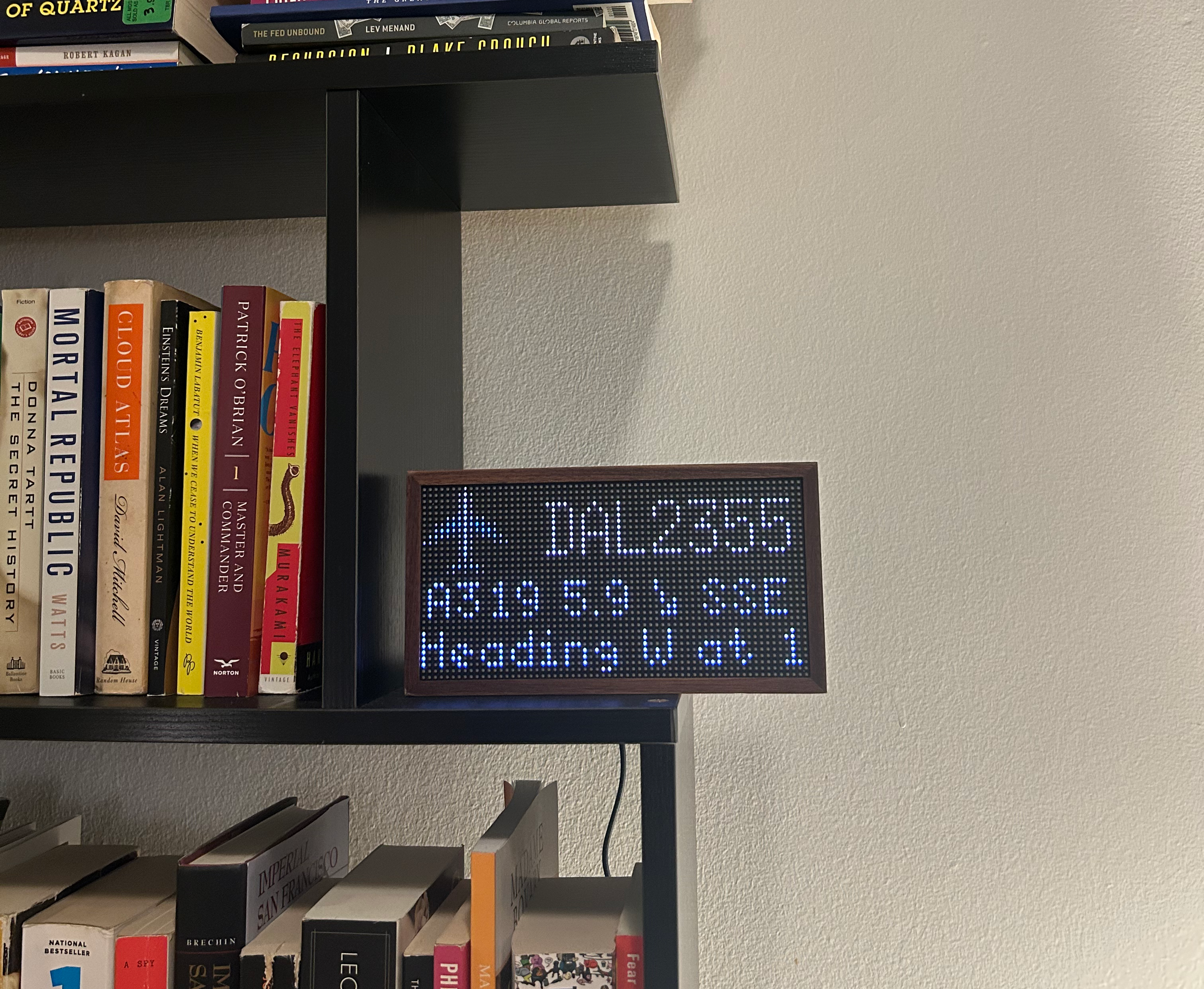
The app is available in the Tidbyt App Store as “Planes Overhead”, with the code available here in the Community repository!
Detailing the Publishing Process
After finishing off the core logic and application code, it took quite a bit of time and attention to massage everything into the “bundle” that the Tidbyt team requires for the app to be exposed in their community app store.
Parameterizing Inputs from Users to Make the App Flexible
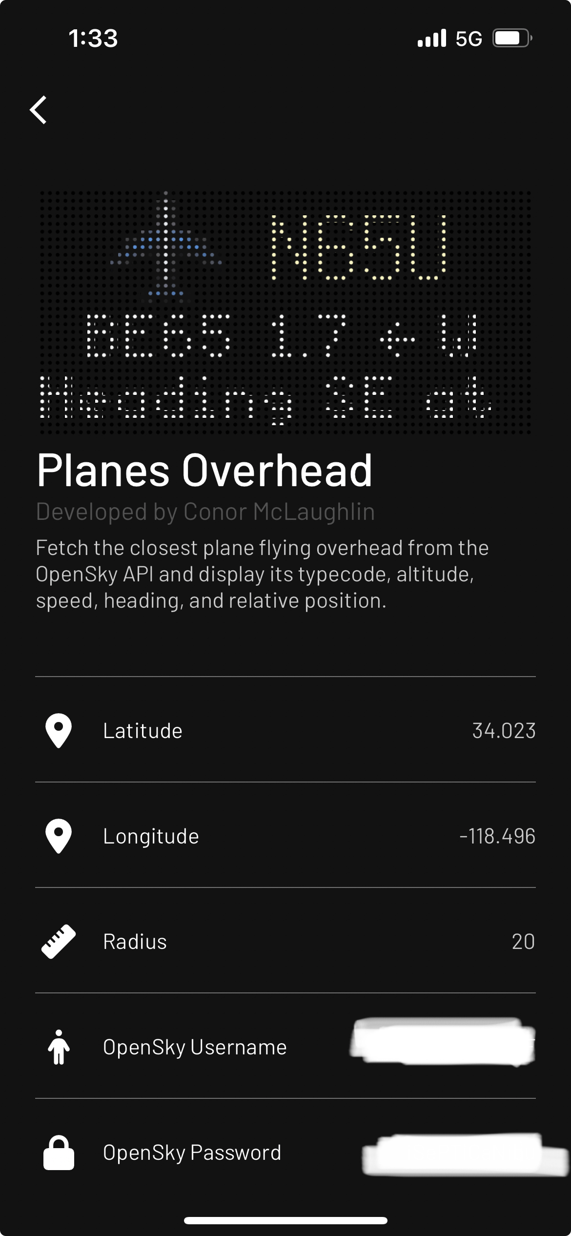
One of the simplest elements of this was making the app “generic”, and flexible for other users to set up for their locations. This wasn’t too much trouble because Tidbyt’s SDK provides a schema object which users can use to customize how their app installation.
In my case, I just needed to expose a few fields as variables:
lat/lng: so that users can provide their own location above which to fetch planesradius: how broad of an area to search; I figured this might need to be expanded in more rural areas vs a plane-dense place like LA, so I set a reasonable default, but wanted to have this be customizableOpenSky usernameandOpenSky password: for users to sign in with their own OpenSky credentials, so that they can take advantage of their daily 4,000 API request cap.
Here’s how the configuration actually looks within the Tidbyt mobile app on iOS:
Encrypting API Key
Parameterizing out the OpenSky credentials means we don’t have to store an API key for them in the script. However, we need one to authenticate requests to our DBHub database for the airplane model lookup!
To get this working, without simply dumping the key in the script in plaintext, I needed to use the Pixlet secrets feature.
To generate an encrypted key, you run the following task on the command line:
pixlet encrypt planes-overhead <your_secret_api_key_goes_here>
… and then tell your script to use this encrypted key for your secret! Note that this encrypt/decrypt process only happens when running in the Tidbyt cloud, so for local development, you should keep passing the key as a config variable as seen in the last line of code.
ENCRYPTED_API_KEY = "AV6+xWcEh+bIZuAShzxaiN6+d0VmDHBwKTzBRWhGzlklt96UKtoIkoMwtqC7w8oOCbbPAyBn94hirsp0TM2pQ9vzfhDM5I1BEL2wKdUs0HSwtuVLIPzcNgq/2QNc8ANvMK/DFYXM+mzi/vXTmoUmEe19B+Vxt28Jzs3qUL/+L5yYEHHp8n0/VwscJ6Z31WPNe/Z8WirghrFMQxAW"

# for the later call to get airplane model
airplane_db_api_key = secret.decrypt(ENCRYPTED_API_KEY) or config.get("dev_api_key")
Submitting the Code For Review
To publish the app, I followed the instructions on the Tidbyt developers website to a T:
- forking the Community apps repo
- running
pixlet createto define my new app - copying in my code and rendering a preview
pixlet render apps/{{appname}}/{{app_name}}.star --gif --magnify 10- note that if you have a lot of configuration variables (as I do) you also need to specify those as command line arguments to the render command
- creating a pull request to the main repository!
After going through this process to make my initial PR, I found that my app was “installable” thru the Tidbyt app, but did not display correctly on the display!
Fortunately, I was able to debug the issue and determine that I had encrypted the API key in the strap earlier with “planes overhead” as the first argument. However, the manifest.yaml for my app defines the id as planes-overhead - I found that re-encrypting the API with the hyphenated name, and updating the ENCRYPTED_API_KEY in my script did the trick. Everything worked after merging this PR!
Code Reference
Here’s the full dump of my code - hopefully this is a helpful and searchable reference for others who are building semi-complex Tidbyt apps which incorporate API requests and API secrets!
"""
Applet: Planes Overhead
Summary: Show closest overhead plane
Description: Fetch the closest plane flying overhead from the OpenSky API and display its typecode, altitude, speed, heading, and relative position.
Author: Conor McLaughlin
"""

load("encoding/base64.star", "base64")
load("encoding/json.star", "json")
load("http.star", "http")
load("math.star", "math")
load("render.star", "render")
load("schema.star", "schema")
load("secret.star", "secret")

# planesoverhead
ENCRYPTED_API_KEY = "AV6+xWcEh+bIZuAShzxaiN6+d0VmDHBwKTzBRWhGzlklt96UKtoIkoMwtqC7w8oOCbbPAyBn94hirsp0TM2pQ9vzfhDM5I1BEL2wKdUs0HSwtuVLIPzcNgq/2QNc8ANvMK/DFYXM+mzi/vXTmoUmEe19B+Vxt28Jzs3qUL/+L5yYEHHp8n0/VwscJ6Z31WPNe/Z8WirghrFMQxAW"

def get_schema():
    return schema.Schema(
        version = "1",
        fields = [
            schema.Text(
                id = "lat",
                name = "Latitude",
                desc = "Latitude to fetch planes overhead",
                icon = "locationDot",
                default = "32.023",
            ),
            schema.Text(
                id = "lng",
                name = "Longitude",
                desc = "Longitude to fetch planes overhead",
                icon = "locationDot",
                default = "-118.490",
            ),
            schema.Text(
                id = "radius",
                name = "Radius",
                desc = "Rough radius (miles) to search inside",
                icon = "ruler",
                default = "20",
            ),
            schema.Text(
                id = "user",
                name = "OpenSky Username",
                desc = "username of OpenSky account (optional, higher API access limits)",
                icon = "person",
            ),
            schema.Text(
                id = "pass",
                name = "OpenSky Password",
                desc = "password of OpenSky account (optional, higher API access limits)",
                icon = "lock",
            ),
            schema.Text(
                id = "dev_api_key",
                name = "(Not Required - DEV) API Key",
                desc = "for airplane db lookups",
                icon = "lock",
            ),
        ],
    )

def get_bounding_box(lat, lng, radius):
    R = 6371  # earth radius in km
    radius = radius * 1.609
    x1 = lng - math.degrees(radius / R / math.cos(math.radians(lat)))
    x2 = lng + math.degrees(radius / R / math.cos(math.radians(lat)))
    y1 = lat + math.degrees(radius / R)
    y2 = lat - math.degrees(radius / R)
    dict = {"lamin": y2, "lomin": x1, "lamax": y1, "lomax": x2}
    return dict

def get_haversine_distance(lat1, lng1, lat2, lng2):
    # Approximate radius of earth in km
    R = 6373.0

    lat1 = math.radians(lat1)
    lon1 = math.radians(lng1)
    lat2 = math.radians(lat2)
    lon2 = math.radians(lng2)

    dlon = lon2 - lon1
    dlat = lat2 - lat1

    a = math.pow(math.sin(dlat / 2), 2) + math.cos(lat1) * math.cos(lat2) * math.pow(math.sin(dlon / 2), 2)
    c = 2 * math.atan2(math.sqrt(a), math.sqrt(1 - a))

    distance = R * c

    return math.round(distance * 10 / 1.609) / 10

def get_bearing(lat1, long1, lat2, long2):
    dLon = (long2 - long1)
    x = math.cos(math.radians(lat2)) * math.sin(math.radians(dLon))
    y = math.cos(math.radians(lat1)) * math.sin(math.radians(lat2)) - math.sin(math.radians(lat1)) * math.cos(math.radians(lat2)) * math.cos(math.radians(dLon))
    brng = math.atan2(x, y)
    brng = math.degrees(brng)
    return (brng + 360) % 360

def get_heading(value):
    heading = ""

    if value == None:
        heading = "N/A"
    elif value < 11.25:
        heading = "N"
    elif value < 33.75:
        heading = "NNE"
    elif value < 56.25:
        heading = "NE"
    elif value < 78.75:
        heading = "ENE"
    elif value < 101.25:
        heading = "E"
    elif value < 123.75:
        heading = "ESE"
    elif value < 146.25:
        heading = "SE"
    elif value < 168.75:
        heading = "SSE"
    elif value < 191.25:
        heading = "S"
    elif value < 213.75:
        heading = "SSW"
    elif value < 236.25:
        heading = "SW"
    elif value < 258.75:
        heading = "WSW"
    elif value < 281.25:
        heading = "W"
    elif value < 303.75:
        heading = "WNW"
    elif value < 326.25:
        heading = "NW"
    elif value < 348.75:
        heading = "NNW"
    elif value >= 348.75:
        heading = "N"
    return heading

def get_arrow(heading):
    arrow = ""

    if (0 <= heading) and (heading < 22.5):
        arrow = "↑"
    elif (22.5 <= heading) and (heading < 67.5):
        arrow = "↗"
    elif (67.5 <= heading) and (heading < 112.5):
        arrow = "→"
    elif (112.5 <= heading) and (heading < 157.5):
        arrow = "↘"
    elif (157.5 <= heading) and (heading < 202.5):
        arrow = "↓"
    elif (202.5 <= heading) and (heading < 247.5):
        arrow = "↙"
    elif (247.5 <= heading) and (heading < 292.5):
        arrow = "←"
    elif (292.5 <= heading) and (heading < 337.5):
        arrow = "↖"
    elif (337.5 <= heading) and (heading <= 360):
        arrow = "↑"
    else:
        arrow = "·"

    return arrow

def get_typecode(icao24, api_key):
    print("Looking up ICAO24: " + icao24)

    DBOWNER = "cmcl"
    DBNAME = "aircraft.sqlite"
    URL = "https://api.dbhub.io/v1/query"

    query = """
  SELECT typecode
  FROM aircraft
  WHERE icao24 = '%s'
  """ % (icao24)

    query_base64 = base64.encode(query)

    params = {
        "apikey": api_key,
        "dbowner": DBOWNER,
        "dbname": DBNAME,
        "sql": query_base64,
    }

    query_post = http.post(
        url = URL,
        form_body = params,
    )

    print("Type Lookup HTTP Status:", +query_post.status_code)

    post_response = query_post.body()

    typecode = json.decode(post_response)[0][0]["Value"] if len(post_response) > 0 else ""

    return typecode

def render_error(status_code):
    screen = render.Root(
        child = render.Column(
            cross_align = "center",
            children = [
                render.Row(
                    children = [
                        render.Image(src = http.get("https://cdn-icons-png.flaticon.com/256/683/683094.png").body(), height = 15),
                        render.Text(content = "     ", height = 15, offset = 1, font = "6x13", color = "#fcf7c5"),
                    ],
                ),
                render.WrappedText(content = "HTTP" + str(status_code), color = "#f7ba99"),
            ],
        ),
    )
    return screen

def process_states(state_list, your_coord):
    output = []
    if len(state_list) > 0:
        for item in state_list:
            temp = {}
            temp["icao24"] = item[0]
            temp["callsign"] = item[1].strip()
            temp["origin_country"] = item[2]
            temp["time_position"] = item[3]
            temp["last_contact"] = item[4]
            temp["lng"] = item[5]
            temp["lat"] = item[6]
            temp["dist_from_you"] = get_haversine_distance(item[6], item[5], your_coord[0], your_coord[1])
            temp["location_vs_you"] = get_heading(get_bearing(your_coord[0], your_coord[1], item[6], item[5]))
            temp["arrow"] = get_arrow(get_bearing(your_coord[0], your_coord[1], item[6], item[5]))
            temp["on_ground"] = item[8]
            temp["speed"] = None if item[9] == None else math.round(item[9] * 2.23694)
            temp["track"] = item[10]
            temp["heading"] = get_heading(item[10])
            temp["climb"] = None if item[11] == None else "ascending" if item[11] > 0.5 else "descending" if item[11] < -0.5 else "stable"
            temp["altitude"] = None if item[13] == None and item[7] == None else math.round((item[13] or item[7]) * 3.28)
            temp["category"] = None if item[17] == None else "H" if item[17] == 6 else "L" if item[17] == 5 else "M" if item[17] == 4 else "S" if item[17] == 4 else "-"
            if temp["callsign"] != None and temp["on_ground"] == False:
                output.append(temp)
        output = sorted(output, key = lambda i: i["dist_from_you"])
    return output

def render_empty():
    screen = render.Root(
        child = render.Column(
            cross_align = "center",
            children = [
                render.Row(
                    children = [
                        render.Image(src = http.get("https://cdn-icons-png.flaticon.com/256/683/683094.png").body(), height = 15),
                        render.Text(content = "     ", height = 15, offset = 1, font = "6x13", color = "#fcf7c5"),
                    ],
                ),
                render.WrappedText(content = "No Planes Overhead", color = "#f7ba99"),
            ],
        ),
    )
    return screen

def render_plane(planes, api_key):
    print(planes[0])
    typecode = get_typecode(planes[0]["icao24"], api_key)
    print(typecode)
    screen = render.Root(
        render.Column(
            cross_align = "center",
            children = [
                render.Row(
                    children = [
                        render.Image(src = http.get("https://cdn-icons-png.flaticon.com/256/683/683094.png").body(), height = 15),
                        render.Text(content = " %s" % planes[0]["callsign"], height = 15, offset = 1, font = "6x13", color = "#fcf7c5"),
                    ],
                ),
                render.Text(content = "%s %s %s %s" % (typecode, planes[0]["dist_from_you"], planes[0]["arrow"], planes[0]["location_vs_you"])),
                render.Marquee(
                    child = render.Text(content = "Heading %s at %d mph, Altitude %d ft and %s" % (planes[0]["heading"], planes[0]["speed"], planes[0]["altitude"], planes[0]["climb"])),
                    scroll_direction = "horizontal",
                    offset_end = 64,
                    width = 64,
                    delay = 100,
                ),
            ],
        ),
    )
    return screen

def main(config):
    lat = float(config.str("lat", "34.023"))
    lng = float(config.str("lng", "-118.496"))
    your_coord = [lat, lng]

    username = str(config.get("user"))
    password = str(config.get("pass"))
    credentials = (username, password)

    radius = float(config.str("radius", "20"))
    bbox = get_bounding_box(lat, lng, radius)

    # for the later call to get airplane model
    airplane_db_api_key = secret.decrypt(ENCRYPTED_API_KEY) or config.get("dev_api_key")

    params = {
        "lamin": str(math.round(bbox["lamin"] / .001) * .001),
        "lomin": str(math.round(bbox["lomin"] / .001) * .001),
        "lamax": str(math.round(bbox["lamax"] / .001) * .001),
        "lomax": str(math.round(bbox["lomax"] / .001) * .001),
        "extended": "1",
    }

    api_result = http.get(
        url = "https://opensky-network.org/api/states/all",
        params = params,
        auth = credentials,
    )
    api_status_code = api_result.status_code
    api_response = api_result.json()

    # testing a non-good HTTP return code
    # api_status_code = 400

    # testing an empty states list
    # api_response["states"] = []

    if api_status_code != 200:
        return render_error(api_status_code)
    elif "states" not in api_response.keys():
        return render_empty()
    elif "states" in api_response.keys():
        state_list = [] if api_response["states"] == None or len(api_response["states"]) == 0 else api_response["states"]
        planes = process_states(state_list, your_coord)
        if len(planes) == 0:
            return render_empty()
        else:
            return render_plane(planes, airplane_db_api_key)
    else:
        return render_empty()